NEWS • 2026-03-30
A robot-assisted pipeline to help scan aerial photographs
In the 1900s, aerial surveys captured hundreds of millions of high-resolution images of the Earth’s surface. The information contained in these images could help to provide insights into the environmental and social upheavals of the 20th century, long before modern satellite imagery. Until today, retrieval of these images has been difficult and costly as the vast majority sit in physical archives. A new study presents a novel robot-assisted pipeline that can help human workers scan and digitize images up to 30 times faster.
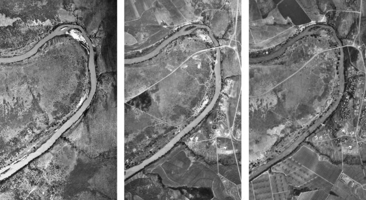
The changing landscape at Big Bend, Swaziland, chronicled in DOS aerial photography. Copyright: National Collection of Aerial Photography
While aerial photography holds great potential to help us understand the twentieth century, a time of great change and upheaval, access to physical archives remains extremely limited. Manual digitization remains prohibitively costly and time-consuming. A new article co-authored by Beijer Institute researcher Anna Tompsett presents a robot-assisted pipeline that can help significantly speed up this process.
Researchers worked with an archive of 1.7 million images, held and curated since 2012 by the National Collection of Aerial Photography (NCAP) in Edinburgh, UK. This archive maps more than 5 million km2 of the earth’s land surface, primarily land across the African continent that was photographed and mapped during the end of the colonial era and the first decades of independence. Scanning the archive manually would require approximately 10 person-years of tedious, physically demanding labour, even with fast, modern scanners. Additionally, the manual scanning process is extremely monotonous and physically demanding, increasing the risk of injury to workers.
Leveraging both human and robot strengths
To address this challenge, the team at NCAP developed a robot-assisted pipeline to allow digitization at scale. The pipeline makes use of an adapted robotic scanner arm used as a “cobot”, or collaborative robotic system. The pipeline splits the digitization process into two parts: a preservation pipeline, which relies on the nuance and judgment of human workers to prepare prints for scanning, and a scanning pipeline, in which the prints are scanned by a robot scanner to create a digital copy.
The pipeline is an example of a well-planned division of labour between humans and robots. The preservation stage involves manually inspecting prints for signs of damage and taking the right remedial action. This may include removing mould, separating prints that are stuck together, humidifying and flattening curled prints, and more – tasks that are difficult to outsource to a robot. The scanning stage, on the other hand, involves a large number of identical repeated tasks – this is where the team saw the potential to introduce robot-assisted scanning to accelerate the scanning process.
A thirty-fold increase in worker productivity
The study reveals that use of a robot-assisted scanning pipeline led to a thirty-fold increase in worker productivity. Human workers can, in principle, achieve higher scanning rates per scanner-hour than a robot scanner. One human worker, however, can only load and unload scanners during working hours, while robotic scanners can work around the clock. Reducing time on scanning per worker-day to two hours spent loading and troubleshooting robotic scanners also frees up remaining hours for other tasks.
The authors note that the theoretical maximum production rates are unlikely to be achieved in practice by either robotic or human systems. For instance, if a robotic system encounters a problem outside of human working hours, it may only be resolved the next working day. Humans may be distracted or need to take breaks and sick days, and new workers will need training and time to learn the process. The system nonetheless achieved the theoretical maximum daily productivity on its most productive days.
Unlocking access to aerial photography archives
While the method developed holds great potential to increase access to aerial photography archives, automation requires considerable up-front investment in infrastructure. The researchers estimated that automation becomes cost-effective when scanning more than 2.4 million images, and halves costs compared to manual scanning when scanning more than 5 million images. Yet, when the project began, two of the largest archives worldwide – the NCAP and the United States National Archives and Reports Administration (NARA) had respectively digitized only about 2% and 0.5% of their aerial photography.
This means that there may be a high demand for this type of technology, which can revolutionize our understanding of the 20th century, drawing on the strength of both humans and technology to help us better understand the historical developments of the biosphere. At the same time, we need new models for collaboration across archives, given than the robotic system will not be cost-effective for smaller archives to adopt independently.
“This is just the first step of making these images available”, says Anna Tompsett. “Our team are working on automating the georeferencing process and the process of extracting information from the images for analysis. But beginning to unlock these data is extraordinarily exciting – it’s like having a time machine to fly back through time and see exactly how the world was a lifetime ago.”
Reference: Masson, S., A. Potts, A. Williams, S. Berggreen, K. McLaren, S. Martin, E. Noda, N. Nordfors, N. Ruecroft, H. Druckenmiller, S. Hsiang, A. Madestam and A. Tompsett. 2026. A robot-assisted pipeline to rapidly scan 1.7 million historical aerial photographs. npj Heritage Science 14:123
NEWS